Download the Steering Group Objection Letter Objection letter to WDC incl Appendix.
We, Stop Ardenvale/Little Wold, Development Steering Group are objecting to the development proposed in application number WD/2021/2568. We are all residents of Groombridge, and our names and addresses are at the end of this document.
WE OBJECT TO THIS DEVELOPMENT ON THE FOLLOWING GROUNDS:
Point 1A
That there should be no major development in High Weald Area of Outstanding Beauty (AONB).
Point 1B
That the proposed development is a major development within the AONB being a proposal for 21 houses, a major development being defined as more than 10 dwellings.
Point 2
That the new major development is outside the settlement boundary of Groombridge village set in 1987 since that date never changed in any Wealden Local Plan.
Point 3
The proposed development will have an impact upon the AONB, the landscape character and visual amenity of the area. The proposed development will damage the tranquillity of the AONB.
Point 4
That the proposed new access road is dangerous, joining a substandard narrow rural road with inadequate visibility. It will cross and impede Back Lane, an ancient byway, making it unacceptably dangerous for all users, i.e. pedestrians, disability scooters, cyclists, and horse riders.
Point 5
That the proposed development will breach the dark skies policy of the High Weald AONB.
Point 6
That the development will require the environmentally damaging demolition of a 4-bedroom family home and stable, both providing roosts for endangered species. The proposed development will destroy habitat for protected species.
Point 7
That the development will be a separate ‘estate’ that you travel into which is in breach of the High Weald AONB Design guide section headed Permeability.
In addition:
Point 8:
There are potentially insufficient sewerage facilities.
Each point is given fuller explanation in the following pages.
Introduction:
The National Planning Policy Framework (NPPF) states:
Paragraph 24: Local planning authorities and county councils (in two-tier areas) are under a duty to cooperate with each other, and with other prescribed bodies, on strategic matters that cross administrative boundaries.
The village of Groombridge as a whole, lies in two administrative areas, Wealden District Council (East Sussex) and Tunbridge Wells Borough Council (Kent).
Wealden District Council is urged to work with Royal Tunbridge Wells. In 2021 the developers of Burrswood, Martin Homes, have been granted change of use permission to alter the main building into 72 self-contained assisted living units. Further it is the intention of Martin Homes to apply for an additional 30 houses on the land adjacent to the main site, making use of redundant buildings and new build. If this permission is granted it will have a profound effect on the nature of the community with additional pressures on the creaking infrastructure of Groombridge. If permission is granted for both developments and 21 houses are added in East Sussex this will amount to an approximately 20% increase in the population of 1700.
All the facilities of the village, save one public house, lie in East Sussex.
OBJECTIONS
POINT 1A: THAT THERE SHOULD BE NO MAJOR DEVELOPMENT IN THE HIGH WEALD AREA OF OUTSTANDING BEAUTY (AONB)
View of the potential development plot from Back Lane, in 2016 when the hedges were lower than at present.
- Paragraph 11 of the NPPF may state that the presumption in favour of sustainable development, but that paragraph should be read in conjunction with Paragraph 177 of the 2021 NPPF, which states: When considering applications for development within National Parks, the Broads and Areas of Outstanding Natural Beauty, permission should be refused for major development.
- The development, as proposed, will permanently alter a landscape that has existed since medieval times which is one of the prime reasons for the decision in 1983 to create the High Weald AONB.
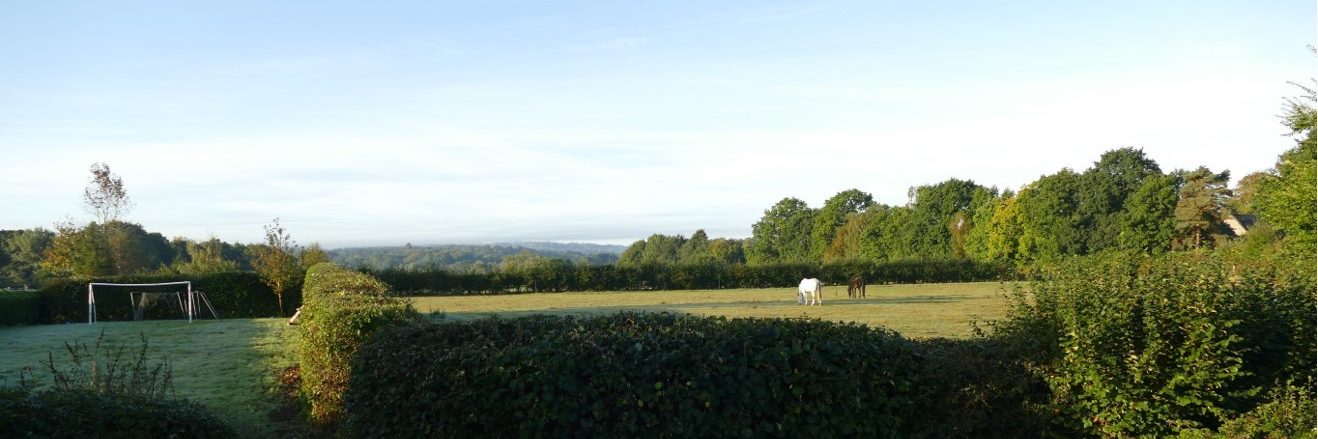
- The land is at present used in a way that is entirely consistent with the policies of the High Weald AONB, in that is used for grazing horses in a peaceful and tranquil manner within small field boundaries; key distinguishing features of the High Weald AONB.
- The land has in relatively recent memories been either used for growing cereal crops or for growing hops, evidence of which still exist today. The present use of grazing for animals is a natural progression of the country life at the present time.
- The land abuts Ancient Woodland (Ayttons Wood) to the south which, in turn, sits above another feature of the High Weald AONB, a sandstone outcrop known as Harrison Rocks, now used for climbing and leisure walking. A development on top of these precious resources will permanently change the character of this part of the AONB.
- Only 50 % of the total land mass that comprises Wealden is within the AONB. Therefore, there should be a stronger presumption to refuse planning permission in an area that lies within the AONB and a presumption in favour of developing in that part of Wealden not within the AONB. This has been the underlying policy of the council since 1983.
- Groombridge already has a large number of accessible public open spaces including the recreation ground, the Tanyard, Harrison Rocks, Broadwater Warren and the Forest Way Country Park, plus many footpaths for which the High Weald is renown. The proposed development does not add anything significantly to the public open spaces of this village.
Permission should be refused on the grounds that it is on green field land within the High Weald AONB.
POINT 1B: THAT THE NEW DEVELOPMENT IS A MAJOR DEVELOPMENT WITHIN AN AONB BEING A PROPOSAL FOR 21 HOUSES, A MAJOR DEVELOPMENT BEING DEFINED AS MORE THAN 10 DWELLINGS
The National Planning Policy Framework (NPPF) Annex 2: Glossary, published by the Ministry of Housing, Communities & Local Government (MHCLG) in 2012, defines a major development as: ‘For housing, development where 10 or more homes will be provided, or the site has an area of 0.5 hectares or more.
There is a heavy reliance on footnote 60 to Paragraph 177 that whether or not it is a major development is a matter for the decision maker taking into account its nature, scale and setting and whether it could have any significant adverse impacts on the purpose for which the area has been designated. It is suggested that 21 homes are not major for Groombridge. However, no mention has been made of the 72 new units on the Kent side of Groombridge in an existing building, known as Burrswood. This will have a huge impact on the village as a whole in terms of access to the infrastructure putting the sustainability of this planning proposal in doubt.
Consideration should be given to the fact that all previous Wealden Development Plans have listed Groombridge as one of a handful of villages that are not suitable for any large-scale development.
Furthermore, the above definition of a major development has remained unchanged for many years.
Therefore, applying all the relevant facts and context and properly applying the intention of the NPPF this proposal should be refused planning permission as it is a major development within an AONB.
POINT 2: THAT THE NEW MAJOR DEVELOPMENT IS OUTSIDE THE SETTLEMENT BOUNDARYOF GROOMBRIDGE VILLAGE SET IN 1987 SINCE THAT DATE NEVER CHANGED IN ANYWEALDEN LOCAL PLAN
In paragraph 5.2.3 of the Planning Statement the developers allege that the ‘settlement boundary for Groombridge is considered out of date given the district’s lack of a five-year supply’. It is alleged that 21 houses will ‘provide a significant supply of housing’. In common parlance this does not make sense or indeed stand up to examination. There are over 2000 unfulfilled planning permissions that have been granted within Wealden at the present time which will have a significant impact on the supply once completed.
The settlement boundary has been in place since 1987 and in all previous planning policies Wealden has seen no need to alter this boundary.
Historically the settlement boundary was placed along Back Lane to ensure the integrity of the village and surrounding countryside in an AONB. It will completely ruin open countryside adjacent to the settlement boundary.
Permission should be refused on the grounds that it is outside the settlement boundary.
POINT 3: THE PROPOSED DEVELOPMENT WILL HAVE AN IMPACT UPON THE AONB, THE LANDSCAPE CHARACTER AND VISUAL AMENITY OF THE AREA.
The ‘tranquillity’ of the site’ it is argued is not affected by the development. This is incorrect and we object on the grounds that there would be considerable loss of amenity in terms of rural aspects and views across the High Weald AONB, one of the key benefits of the AONB.
The suggestion that there will be a high level of visual enclosure relies on the new houses maintaining the extreme height of the vegetation surrounding the field. Whilst we know of no law that requires mixed boundary hedges to be of a certain low height, the hedges at the moment are exceptionally high and show signs of disintegration that are likely to continue and will allow the site to become highly visible overpowering Back Lane, the Southern footpath and all surrounding homes.
The Landscape and Visual Impact statement has taken no account of the height of the field in relation to the surrounding houses on all sides.
The photograph is taken from the private garden adjacent to the proposed development and shows clearly the height of the field in relation to existing dwellings
The field is over a metre higher than Back Lane and several metres higher than the houses in
Lealands Close. Privacy is lost to all houses adjoining Back Lane, including the ones sited in Station Road. A site visit will show that the base of the proposed houses will start at first floor level of the existing homes in Lealands Close and overshadow all the private gardens abutting the field (visible in the photo above).
POINT 4: THAT THE PROPOSED NEW ACCESS ROAD IS DANGEROUS, JOINING A
SUBSTANDARD NARROW RURAL ROAD WITH INADEQUATE VISIBILITY. IT WILL CROSS AND IMPEDE BACK LANE, AN ANCIENT BYWAY, MAKING IT UNACCEPTABLY DANGEROUS FOR ALL USERS, I.E. PEDESTRIANS, DISABILITY SCOOTERS, CYCLISTS AND HORSE RIDERS.
In relation to point 4 we rely on the following paragraphs from the NPPF:
- In assessing sites that may be allocated for development in plans, or specific applications for development, it should be ensured that:
- appropriate opportunities to promote sustainable transport modes can be – or have been – taken up, given the type of development and its location;
- safe and suitable access to the site can be achieved for all users;
- Development should only be prevented or refused on highways grounds if there would be an unacceptable impact on highway safety, or the residual cumulative impacts on the road network would be severe.
- Within this context, applications for development should:
- give priority first to pedestrian and cycle movements, both within the scheme and with neighbouring areas; and second – so far as possible – to facilitating access to high quality public transport, with layouts that maximise the catchment area for bus or other public transport services, and appropriate facilities that encourage public transport use;
- address the needs of people with disabilities and reduced mobility in relation to all modes of transport;
- create places that are safe, secure and attractive – which minimise the scope for conflicts between pedestrians, cyclists and vehicles, avoid unnecessary street clutter, and respond to local character and design standards;
- allow for the efficient delivery of goods, and access by service and emergency vehicles; and
- be designed to enable charging of plug-in and other ultra-low emission vehicles in safe, accessible and convenient locations
Sustainable transport
All the houses will need a car, or more likely more than one car, and the suggested methods of sustainable transport are unrealistic and impracticable because:
- Groombridge sits in a valley at the bottom of several steep hills.
- Cycling is not a realistic option.
- It seems that the transport assessment was done without looking properly at the contours of the surrounding land or the narrowness of access roads, all which are dangerous for social or commuting cyclists. The recent death of a local resident cycling within Groombridge has sadly proved this point.
- Eridge Railway Station is approached by a single-track road, with high banks, limited passing areas, on a steep hill with a blind bend at the bottom. Daily commuting by bicycle is potentially dangerous.
- The bus service is limited, with one bus an hour on weekdays.
- The last bus from Tunbridge Wells is early evening, difficult for late commuting.
- The service on Sunday comprises 4 buses in the whole day.
- The bus stop is at least 700m distant from the new development and Google maps suggest the time to walk from the bottom of Lealands Close to the bus stop is at least 9 minutes along a road without a pavement. From the proposed new houses which are further on from Lealands Close the route is only partially pavemented and walking will take at least 5 minutes longer. Returning home loaded with shopping would be a continuous uphill walk taking somewhat longer.
Traffic Data
Groombridge is considered a service centre, under planning criteria. This means it has a more limited supply of social and economic infrastructure including employment, and where local residents depend upon other centres to meet a broad range of needs with some form of accessibility to those centres.
The TRICS data used by Motion in the transport statement to support their estimate of a peak of 12 two-way vehicle movements is from suburban areas and therefore entirely inappropriate for use in a rural service centre setting. The data provided by the applicant is not relevant to this application and is therefore misleading.
Highway Safety
There is an unacceptable impact on highway safety (para 111 NPPF) for the following reasons:
- No changes have been made to the road since 2017 when it was deemed in Wealden District Council SHELAA as substandard.
- The road is single track, cars queue at the point of proposed access all through the day.
- The road is so narrow approaching the proposed new access that two vehicles cannot pass each other safely (see above).
- Traffic speeds are low because of the narrow road (see above).
- There is a 9-tonne limit on the humpback bridge in Station Road over the railway meaning large vehicles are not permitted through the village and can only access the proposed site via the winding country lanes through the Broadwater Forest.
- There is a blind corner at the junction at Station Road with Eridge Road.
- The Station Road traffic count provided by the developers in the application is misleading as it was completed during lockdown (January 2021). Attached at Appendix 1 is a count taken by ESCC in June 2021 which is probably still marginally below present traffic flows but show vastly increased traffic levels compared to those shown in the application. This information is in the public domain and could have been used by the developers.
- The sight lines are limited at the proposed new access road.
- The proposed access is immediately adjacent to Lealands Close and opposite a multipurpose access for 3 houses, and another drive, therefore the access would result in a large number of cars from both sides accessing Station Road at a very narrow dangerous point.
- The road at the proposed access point does not measure 6 metres as stated in the application. It measures between 4.47 metres and 5.18 metres and is a single-track road.
- The proposed access road is only 4.8 m wide which is likely to result in traffic backing up onto Station Road as two transit vans (or a refuse lorry and a SUV) will be unable to pass each other on the access road. One may have to reverse onto Station Road in breach of the Highway Code. It is insufficient access for emergency vehicles.
- There would be insufficient turning circle for large vehicles, including collection vehicles. At present the refuse collection vehicles reverse up Lealands Close blocking Station Road.
- The refuse collection vehicle cannot go over the humpback bridge and reverses up Station Road to Lealands Close to turn round to go back the way they come.
- There is no pedestrian footpath along Station Road making the pavement on the new access road a pavement to nowhere.
- The increased traffic levels will add to the danger of pedestrians and cyclists who choose to use Station Road or who are visitors who do not know about Back Lane.
- No consideration has been made in any of the traffic information for the disabled access other than by car.
CROSSING POINT ON BACK LANE
- The plans do not show fully how the access road will cross over Back Lane, itself an ancient
- This lane is used daily by residents and visitors walking in the village, children going to school, bicycles and horses avoiding dangerous Station Road. It is part of the National Cycle Network.
- On one day on a typical warm weekend in Summer 2021 with vegetation obscuring part of the ‘BOAT’ 95 people were observed walking, cycling or riding up and down Back Lane.
- It is an essential route for push chairs and disability vehicles.
- There are high hedges that will obscure sight lines for vehicles using the new access road. The red lines denote the proposed crossing point.
Further it is unclear how steep the access road will be and how it will deal with the large differential in height between Back Lane and the proposed new housing estate.
The application should be refused on the grounds that there will be an unacceptable impact on highway safety, fails to give priority to pedestrians and cyclists, fails to meet the needs of people with disabilities, increases the scope for conflicts between pedestrians, cyclists and vehicles and does not allow for safe delivery of goods or access by emergency vehicles.
POINT 5: THAT THE PROPOSED DEVELOPMENT WILL BREACH THE DARK SKIES POLICY OFTHE HIGH WEALD AONB
The following quote is lifted from the High Weald AONB website: The High Weald has been marked as Silver Tier International Dark Sky Reserve, described by the International Dark Sky Association as being: “Night-time environments that have minor impacts from light pollution and other artificial light disturbance, yet still display good quality night skies and have exemplary night-time lightscapes…..The unusually dark skies over the High Weald AONB have been identified as worthy of conservation by the International Dark Sky Association (IDSA). However light pollution is rapidly increasing, and our dark skies may not exist for much longer.
Dark skies are ever more important. Even street lighting dilutes the sky and you cannot see it. At present the view across the development field looks like this at night on a moonless night. The white dots represent Crowborough lights and the thin grey line is the horizon with a large tree.
There is little or no light pollution. Dark skies are essential to the tranquillity of the AONB. The Parish Council now switches off the few lights in the village at midnight. Dark skies are essential for the night-time creatures, such as bats and owls known to be present.
Wealden District Council Planning Committee have recently refused floodlights on the tennis courts even though these would only be lit occasionally for a limited period.
Even without street lighting the proposed houses will cause their own light pollution with lights shining from the windows, dressed or not.
The development should be resisted on the grounds that it breaches the dark skies policy of the High Weald AONB.
POINT 6: THAT THE DEVELOPMENT WILL REQUIRE THE ENVIRONMENTALLY DAMAGING
DEMOLITION OF A 4-BEDROOM FAMILY HOME AND STABLE, BOTH PROVIDING ROOSTS FOR ENDANGERED SPECIES. THE PROPOSED DEVELOPMENT WILL DESTROY HABITAT FOR PROTECTED SPECIES.
From the NPPF: 120. Planning policies and decisions should: …..
- b) recognise that some undeveloped land can perform many functions, such as for wildlife….
- Planning policies and decisions should contribute to and enhance the natural and local environment by:
- a) protecting and enhancing valued landscapes, sites of biodiversity or geological value and soils (in a manner commensurate with their statutory status or identified quality in the development plan); b) recognising the intrinsic character and beauty of the countryside, and the wider benefits from natural capital and ecosystem services – including the economic and other benefits of the best and most versatile agricultural land, and of trees and woodland;
Little Wold is a substantial 4-bedroom family home not a chalet bungalow as described in the application. The only reason for demolition is to construct to an inappropriate access road in a dangerous position. There has been a limited ecological survey of the house and site that has shown that long-eared bats roost in the house, and it is admitted in the survey that the demolition will have an impact on the bat population.
No unnecessary demolition should occur of a perfectly usable family home particularly as the result will be to damage the intrinsic character and beauty of the countryside and the wider benefits of the present ecosystem. The demolition is not commensurate with the statutory status of AONB.
Further, the development itself will interfere with a delicate ecosystem, built up from years of agricultural use from the medieval times to the present. There is clearly deep concern from Nature Space about the proximity of great crested newts and it is designated a red impact zone. Due weight should be given to this concern by the Wealden District Planning Committee.
It is interesting to note that recommendations for additional research seem to have been largely ignored by the developers.
The proposed development will continue for future generations to have a severe impact on this ecosystem, something that in reality is highly unlikely to be properly mitigated.
Putting access points in existing hedges as proposed in the application damages connectivity for existing wildlife, some of which are on the register of protected species.
The application should be refused on the grounds of the damage to Protected Species and their related ecosystem.
POINT 7: THAT THE DEVELOPMENT WILL BE A SEPARATE ‘ESTATE’ THAT YOU TRAVEL INTO WHICH IS IN BREACH OF THE HIGH WEALD AONB DESIGN GUIDE SECTION HEADED PERMEABILITY.
The High Weald Housing Design Guide states that: settlements (within the High Weald) are typically highly permeable in layout linking in to the routeway network and criss-crossed by routes for vehicles and pedestrians. To maintain this characteristic, it is important for new development to site successfully as an integrated piece of the village that people can walk and travel through, rather than a separate ‘estate’ that they travel into…….
The proposed development is a separate housing estate, wholly different in character to the rest of the village in design, layout and roadways. It will only be travelled into not through by the nature of its design. The site has distinct boundaries, Back Lane, the Railway and the Southern footpath and the Livery, surrounded by high hedges and divided from the village by extra planting. The provision of footpaths through the estate does not ameliorate the fact that it is a hidden group of houses that sit as a single housing estate outside the agreed and longstanding village settlement boundary in green field AONB land.
POINT 8: THERE ARE POTENTIALLY INSUFFICIENT SEWERAGE FACILITIES.
- The present sewer in Station Road is possibly at maximum capacity.
- On or about 6 November 2006 a planning application made by a local resident included an application to change an existing sewer (but not increase sewerage). The application was initially refused on the grounds that Southern Water said there was insufficient capacity for an additional connection to the existing sewer. Permission was granted once it was realised that there was no additional sewerage requirement.
- No works have been done since that date to improve the sewer capacity, so it is unlikely that there is sufficient capacity for an additional 21 houses in a small Victorian sewerage system, that was deemed insufficient in 2006.
INFRASTRUCTURE
Green space:
Part of the village charm is the large amount of green space easily available to residents. Harrison
Rocks, Broadwater Forest, Ashdown Forest (a short distance away), the recreation ground, the Tanyard and Forest Way Country Park, not to forget the numerous footpaths. There is no need for additional green space in Groombridge.
School capacity
From discussion with the school, there is only a limited amount of space in Reception and Year 1 (4- and 5-year-olds) and the remainder of the school is completely full. This is of limited value to families potentially moving into the village.
The increased traffic that will undoubtedly be created by parents dropping off and collecting their children, will make an already extremely difficult traffic problem outside the school at present, untenable.
New school playing field
The school has not requested this. The school has used the Tanyard for many years and invested money (along with WDC, ESSC and the Parish Council) in the development of proper changing facilities. The walk to the Tanyard for the older children (the younger ones do not use it) is part of the PE fitness programme.
The younger children do not go to the Tanyard because of the 3:1 ratio that is needed to escort them. This would still be the case if the playing field was across the bridge, and they would have to negotiate long steep steps on both sides of the bridge. There are no changing or lavatory facilities in the plans and the playing field is on the boggy part of the fields that flood in winter, making it wholly unusable. There is no access provision for the disabled.
Doctor’s Surgery
The offshoot of the Groombridge and Hartfield practice at The Nook has not been open since the start of Covid and, as far as it is known, there are no plans to open this surgery soon. Everyone in Groombridge has to drive to Hartfield for appointments and to use the dispensary.
Affordable Housing
Whilst the application states that 7 of the 21 houses will be affordable there is no statement about preferred social housing providers, or no joint statement from a preferred social housing partner which does not bring confidence that there will be reasonable rentable or shared housing provision properly made. It is not clear from the developer’s website whether they are used to working with Social Housing providers.
CONCLUSION
In October 2021 the Prime Minister said: the homes young families need should go not on green fields, not just jammed into the Southeast but on brownfield sites in places where homes make sense.
Michael Gove, Secretary of State for Levelling Up, Housing and Communities, defined levelling up as: investing in urban regeneration with new homes on neglected brownfield sites.
The 2021 NPPF has reiterated these principles and therefore for all the reasons set out above this planning application should be refused.
Peter and Mary Symes, Forest Way, Station Road, Groombridge. TN3 9NG
Andrew and Nikki Sturgeon, 3 Lealands Clos, Groombridge TN3 9ND
Colin and Janice Spratt, Little Pippins, 1 Lealands Close, Groombridge, TN3 9ND
Guy and Claire Orridge, Heys Garth, Station Road, Groombridge, TN3 9NB
Peter and Theresa Bell, Ayttons, 1 Birchden Cottages, Eridge Road, Groombridge, TN3 9NJ
Richard and Belinda Gray, Goldsmiths Cottage, Eridge Road, Groombridge, TN3 9ND
Area Surveyed:
Our ref: A5864 Station Road, Groombridge by “Box Cottage”
Grid Ref: 553407, 136927
Monitoring Period: 07 June to 15 June 2021 Methodology:
The survey was carried out using a Speed Detection Radar (SDR), attached to a post at the location.
Results:
The volume and speed of traffic were recorded and the results are displayed as summaries.
The average 85th percentile speed over twenty four hours was recorded as:
A5864 northbound 30 miles per hour
southbound 32 miles per hour
The 85th percentile speed is the speed at, or below, which 85 percent of the traffic is travelling, or viewed another way, the speed that only 15 percent of drivers exceed.
The average speed over twenty four hours was recorded as:
A5864 | northbound | 26 miles per hour |
| southbound | 26 miles per hour |
The average speed is the speed at, or below, which 50 percent of the traffic is travelling, or viewed another way, the speed that only 50 percent of drivers exceed.
Site Number: 00005864
Station Road, Groombridge, by “Box Cottage”
Details Channels
Site Reference: 00005864 Channel 1: Northbound (North)
Grid Reference: 553407,136927 Channel 2: Southbound (South)
Site Configuration:
Interval: 60
Telemetry: No
Location
A5864 NB.jpg A5864 SB.jpg
Northbound
Southbound
All Channels
Northbound
| |||||||||
00:00 |
| 0 | 1 | 1 | 2 | 3 | 3 | 1 | 2 |
01:00 |
| 0 | 0 | 0 | 0 | 1 | 0 | 0 | 0 |
02:00 |
| 0 | 0 | 0 | 0 | 0 | 0 | 0 | 0 |
03:00 |
| 0 | 0 | 1 | 1 | 1 | 0 | 1 | 1 |
04:00 |
| 1 | 0 | 1 | 3 | 1 | 1 | 1 | 1 |
05:00 |
| 1 | 5 | 4 | 4 | 0 | 3 | 4 | 3 |
06:00 |
| 9 | 6 | 18 | 14 | 7 | 2 | 12 | 10 |
07:00 |
| 36 | 47 | 45 | 41 | 20 | 4 | 42 | 34 |
08:00 |
| 57 | 61 | 75 | 72 | 23 | 18 | 66 | 53 |
09:00 | 39 | 47 | 32 | 40 | 32 | 31 | 33 | 38 | 36 |
10:00 | 41 | 33 | 29 | 34 | 38 | 39 | 26 | 35 | 34 |
11:00 | 19 | 42 | 34 | 35 | 36 | 37 | 44 | 33 | 35 |
12:00 | 30 | 30 | 48 | 34 | 42 | 44 | 34 | 37 | 37 |
13:00 | 49 | 36 | 19 | 33 | 33 | 34 | 38 | 34 | 35 |
14:00 | 34 | 26 | 29 | 44 | 35 | 29 | 45 | 34 | 35 |
15:00 | 43 | 66 | 38 | 56 | 49 | 38 | 28 | 50 | 45 |
16:00 | 47 | 62 | 54 | 57 | 38 | 43 | 29 | 52 | 47 |
17:00 | 38 | 34 | 43 | 32 | 44 | 35 | 26 | 38 | 36 |
18:00 | 32 | 37 | 32 | 28 | 30 | 21 | 19 | 32 | 28 |
19:00 | 18 | 20 | 31 | 27 | 42 | 18 | 17 | 28 | 25 |
20:00 | 12 | 12 | 13 | 21 | 23 | 16 | 14 | 16 | 16 |
21:00 | 6 | 12 | 21 | 13 | 14 | 10 | 13 | 13 | 13 |
22:00 | 1 | 2 | 10 | 9 | 4 | 3 | 5 | 5 | 5 |
23:00 | 0 | 1 | 0 | 5 | 5 | 7 | 2 | 2 | 3 |
Total 12H(7-19) |
| 506 | 466 | 513 | 490 | 394 | 344 | 491 | 456 |
16H(6-22) |
| 559 | 537 | 592 | 583 | 445 | 390 | 560 | 519 |
18H(6-24) |
| 562 | 547 | 606 | 592 | 455 | 397 | 567 | 527 |
24H(0-24) |
| 564 | 553 | 613 | 602 | 461 | 404 | 574 | 533 |
AM Peak |
| 08:00 | 08:00 | 08:00 | 08:00 | 10:00 | 11:00 | 08:00 | 08:00 |
|
| 57 | 61 | 75 | 72 | 39 | 44 | 66 | 53 |
PM Peak | 13:00 | 15:00 | 16:00 | 16:00 | 15:00 | 12:00 | 14:00 | 16:00 | 16:00 |
| 49 | 66 | 54 | 57 | 49 | 44 | 45 | 52 | 47 |
Southbound
| |||||||||
00:00 |
| 0 | 0 | 0 | 2 | 1 | 3 | 1 | 1 |
01:00 |
| 0 | 0 | 0 | 0 | 0 | 3 | 0 | 0 |
02:00 |
| 0 | 0 | 2 | 0 | 0 | 0 | 1 | 0 |
03:00 |
| 2 | 0 | 0 | 1 | 2 | 0 | 1 | 1 |
04:00 |
| 0 | 0 | 0 | 0 | 0 | 1 | 0 | 0 |
05:00 |
| 2 | 2 | 3 | 6 | 2 | 4 | 3 | 3 |
06:00 |
| 16 | 15 | 18 | 15 | 3 | 3 | 16 | 12 |
07:00 |
| 54 | 58 | 52 | 50 | 20 | 6 | 54 | 42 |
08:00 |
| 78 | 83 | 84 | 85 | 70 | 39 | 83 | 75 |
09:00 | 61 | 60 | 74 | 75 | 74 | 60 | 42 | 69 | 64 |
10:00 | 48 | 50 | 45 | 59 | 67 | 78 | 51 | 54 | 57 |
11:00 | 52 | 50 | 40 | 56 | 67 | 68 | 57 | 53 | 56 |
12:00 | 46 | 48 | 37 | 51 | 60 | 61 | 63 | 48 | 52 |
13:00 | 45 | 46 | 44 | 52 | 68 | 78 | 54 | 51 | 55 |
14:00 | 61 | 57 | 60 | 49 | 68 | 58 | 47 | 59 | 57 |
15:00 | 63 | 83 | 76 | 92 | 93 | 63 | 33 | 81 | 72 |
16:00 | 76 | 75 | 89 | 85 | 92 | 55 | 40 | 83 | 73 |
17:00 | 55 | 69 | 77 | 78 | 81 | 50 | 33 | 72 | 63 |
18:00 | 44 | 52 | 54 | 60 | 59 | 26 | 31 | 54 | 47 |
19:00 | 25 | 33 | 42 | 38 | 61 | 19 | 16 | 40 | 33 |
20:00 | 21 | 21 | 14 | 28 | 22 | 15 | 16 | 21 | 20 |
21:00 | 5 | 8 | 13 | 18 | 21 | 5 | 3 | 13 | 10 |
22:00 | 3 | 5 | 9 | 12 | 4 | 6 | 1 | 7 | 6 |
23:00 | 0 | 1 | 3 | 3 | 10 | 5 | 3 | 3 | 4 |
Total 12H(7-19) |
| 722 | 737 | 793 | 864 | 687 | 496 | 761 | 712 |
16H(6-22) |
| 800 | 821 | 895 | 983 | 729 | 534 | 851 | 788 |
18H(6-24) |
| 806 | 833 | 910 | 997 | 740 | 538 | 861 | 797 |
24H(0-24) |
| 810 | 835 | 915 | 1006 | 745 | 549 | 866 | 803 |
AM Peak |
| 08:00 | 08:00 | 08:00 | 08:00 | 10:00 | 11:00 | 08:00 | 08:00 |
|
| 78 | 83 | 84 | 85 | 78 | 57 | 83 | 75 |
PM Peak | 16:00 | 15:00 | 16:00 | 15:00 | 15:00 | 13:00 | 12:00 | 16:00 | 16:00 |
| 76 | 83 | 89 | 92 | 93 | 78 | 63 | 83 | 73 |
Total Flow
| |||||||||
00:00 |
| 0 | 1 | 1 | 4 | 4 | 6 | 2 | 3 |
01:00 |
| 0 | 0 | 0 | 0 | 1 | 3 | 0 | 1 |
02:00 |
| 0 | 0 | 2 | 0 | 0 | 0 | 1 | 0 |
03:00 |
| 2 | 0 | 1 | 2 | 3 | 0 | 1 | 1 |
04:00 |
| 1 | 0 | 1 | 3 | 1 | 2 | 1 | 1 |
05:00 |
| 3 | 7 | 7 | 10 | 2 | 7 | 7 | 6 |
06:00 |
| 25 | 21 | 36 | 29 | 10 | 5 | 28 | 22 |
07:00 |
| 90 | 105 | 97 | 91 | 40 | 10 | 96 | 76 |
08:00 |
| 135 | 144 | 159 | 157 | 93 | 57 | 149 | 128 |
09:00 | 100 | 107 | 106 | 115 | 106 | 91 | 75 | 107 | 100 |
10:00 | 89 | 83 | 74 | 93 | 105 | 117 | 77 | 89 | 91 |
11:00 | 71 | 92 | 74 | 91 | 103 | 105 | 101 | 86 | 91 |
12:00 | 76 | 78 | 85 | 85 | 102 | 105 | 97 | 85 | 90 |
13:00 | 94 | 82 | 63 | 85 | 101 | 112 | 92 | 85 | 90 |
14:00 | 95 | 83 | 89 | 93 | 103 | 87 | 92 | 93 | 92 |
15:00 | 106 | 149 | 114 | 148 | 142 | 101 | 61 | 132 | 117 |
16:00 | 123 | 137 | 143 | 142 | 130 | 98 | 69 | 135 | 120 |
17:00 | 93 | 103 | 120 | 110 | 125 | 85 | 59 | 110 | 99 |
18:00 | 76 | 89 | 86 | 88 | 89 | 47 | 50 | 86 | 75 |
19:00 | 43 | 53 | 73 | 65 | 103 | 37 | 33 | 67 | 58 |
20:00 | 33 | 33 | 27 | 49 | 45 | 31 | 30 | 37 | 35 |
21:00 | 11 | 20 | 34 | 31 | 35 | 15 | 16 | 26 | 23 |
22:00 | 4 | 7 | 19 | 21 | 8 | 9 | 6 | 12 | 11 |
23:00 | 0 | 2 | 3 | 8 | 15 | 12 | 5 | 6 | 6 |
Total 12H(7-19) |
| 1228 | 1203 | 1306 | 1354 | 1081 | 840 | 1252 | 1169 |
16H(6-22) |
| 1359 | 1358 | 1487 | 1566 | 1174 | 924 | 1410 | 1307 |
18H(6-24) |
| 1368 | 1380 | 1516 | 1589 | 1195 | 935 | 1428 | 1324 |
24H(0-24) |
| 1374 | 1388 | 1528 | 1608 | 1206 | 953 | 1439 | 1336 |
AM Peak |
| 08:00 | 08:00 | 08:00 | 08:00 | 10:00 | 11:00 | 08:00 | 08:00 |
|
| 135 | 144 | 159 | 157 | 117 | 101 | 149 | 128 |
PM Peak | 16:00 | 15:00 | 16:00 | 15:00 | 15:00 | 13:00 | 12:00 | 16:00 | 16:00 |
| 123 | 149 | 143 | 148 | 142 | 112 | 97 | 135 | 120 |